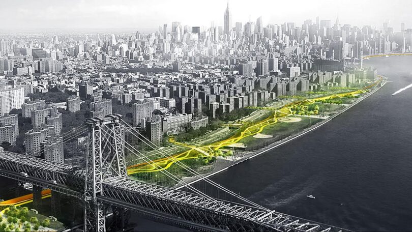
1. The Highway as a Linear Flood Barrier
Big idea: the highway becomes a raised spine that blocks or slows storm surge from the Hudson.
How this works
- Slightly raise or regrade sections of Route 9A over time (especially during reconstruction cycles)
- Integrate floodwalls or berms into medians, guardrails, and adjacent park edges
- Add deployable flood gates at cross streets (similar to Lower Manhattan concepts)
Why Chelsea is suited for this
- The highway already sits between the river and the neighborhood
- Hudson River Park provides space to absorb water before it reaches “buildings
- Less historic fabric right at the edge compared to downtown
Urban design effect:
You don’t see a wall — you see planted slopes, seating edges, bikeways, and subtle grade changes doing flood work quietly.
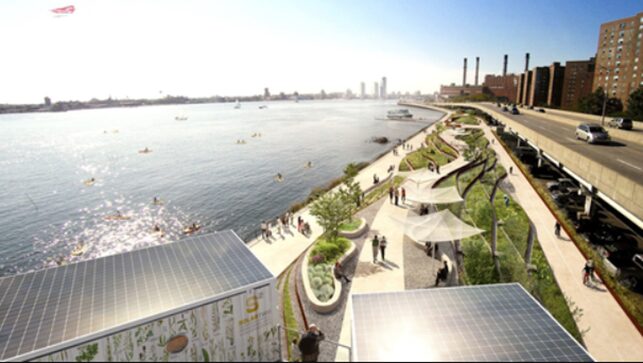
2. Layered Edge Between Highway + Hudson River Park
Rather than one hard line of defense, Chelsea’s west side leans toward multiple softer layers:
Typical section (river → city)
- Living shoreline / reinforced bulkhead
- Floodable park zones (lawns, ball fields, esplanade)
- West Side Highway (reinforced + elevated utilities)
- Raised crossings into Chelsea
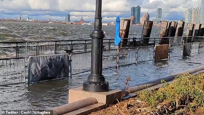
This matters because future floods will be more frequent, not just catastrophic.
Design response:
- Accept that parts of Hudson River Park will flood
- Design them to drain quickly and reopen fast
- Keep the highway and inland neighborhoods dry longer
3. Handling Heavy Rain (Not Just the River)
Chelsea flooding risk isn’t only surge — it’s intense rainfall overwhelming sewers.
Strategies along Route 9A:
- Permeable shoulders and medians to slow runoff
- Subsurface stormwater storage under park areas or widened medians
- Bioswales at crossings (especially where streets slope east → west)
- Detention areas that hold rain during storms and release it later
This is crucial because storm surge + rainfall = compound flooding, which NYC planners now treat as the default future scenario.
4. Reworking Cross Streets (Very Important)
Even if the highway is protected, floodwater can sneak in through street corridors.
Chelsea-specific tactics:
- Slightly raise sidewalk and curb elevations at West Side Highway crossings
- Build “speed bump” flood thresholds where streets meet Route 9A
- Integrate flood gates into street furniture, railings, or planting beds
Urban design win:
Pedestrians barely notice — but during a storm, those inches matter.
5. Designing for Infrastructure Survival
Over 50 years, the priority shifts from “don’t flood” to “flood without failing.”
Along the highway:
- Elevate or waterproof:
- Electrical systems
- Traffic controls
- Pumping stations
- Use salt-tolerant materials
- Design for rapid post-storm reopening
This is huge because Route 9A is an emergency and evacuation corridor.
6. Relationship to Nearby NYCHA & Housing
While Chelsea itself has fewer NYCHA sites than other waterfront areas, lessons still apply:
- Protect the transportation spine first
- Use parkland as sacrificial flood space
- Keep residential connections dry as long as possible
- Avoid putting critical housing systems at grade
Future development near the highway is increasingly expected to:
- Raise first occupied floors
- Treat ground floors as floodable or non-critical
- Align building thresholds with highway protection levels
What This Means Long-Term (50-Year Outlook)
By mid-century, expect the West Side Highway in Chelsea to function as:
A transport corridor
A storm-surge defense line
A stormwater management system
A public landscape edge
All at once.
Leave a Reply